The American Fork Twin Peaks are, not counting sub-peaks on Nebo and Timpanogos, the third highest peak(s) in the Wasatch Range. At 11,489 feet the west twin is the higher of the two peaks. The east twin is 11,433 feet. Two other high peaks are "South Twin Peak" at 11,391 feet and Red Top Mountain (the western-most peak) at 11,360+ feet. They are part of the Snowbird Ski Area, and usually climbed from that resort, or from nearby Alta. They are a short distance from the top of the Snowbird tram (Hidden Peak), but the ridge between the peaks is quite rugged and not for casual hikers.
Since I was climbing this one solo, I opted to climb the peak from Snowbird, via Gad Valley. The route starts at the Snowbird center and follows their trails into Gad Valley. Due to the constantly changing trails here, I'd reccomend checking a trail map at the resort for the best way into the valley.
The trail eventually winds into the Gad Valley side of the mountain. You'll need to get to the Gad II Lift, again consult the latest trail maps. From the lift, there is an obvious saddle about 400 feet above on a grassy slope. It looks pretty easy, but the slope was very steep - more challenging than I had expected.
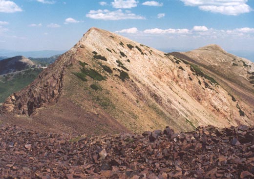
From the ridge, you have a fine view back down into Little Cottonwood Canyon and into White Pine Canyon. From here I began to follow the ridge up towards the first sub-peak called "Red Top Mountain". Quickly I ran into shrubs that were somewhat difficult to negotiate, and at one point I considered abandoning the route and trying the more rugged ridge from Hidden Peak.
I decided to continue, and once past the vegitated area, the hike became much more pleasant. It was steep, and not on trail, but the walking was very easy up grassy slopes with some rock. I just stayed on this ridge all the way puffing up to the peak of Red Top.
From Red Top, you have a fine view to the slightly higher west peak of the American Fork Twins (which is also the highest point in Salt Lake County). Following the ridge from here to the top of the Twin is rocky but easy, and you'll have a chance to peer down the sharp drop into Gad Valley.
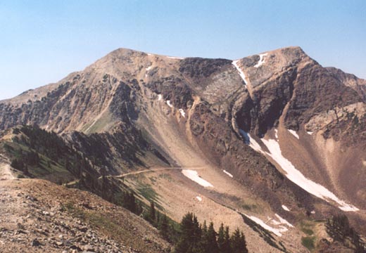
Once on top of the west twin, the peak is flat and wide, and walking to the east twin is easy. The view down Little Cottonwood Canyon is outstanding, as you're above everything nearby. The east twin offers a slightly better view towards the Snowbird tram and a chance to look at the rugged ridge seperating the two peaks. Across the canyon you'll have a fine view of Cottonwood ridge and the numerous avalanche chutes.
The trip down is simple and quick, and the worst part is that 400 foot hill to get back down to the Gad II chairlift. Roundtrip time for the hike was probably around seven hours. It wasn't one of my favorite climbs, but I would like to try it again in the future and climb the ridge from Hidden Peak to see how challenging it really is.
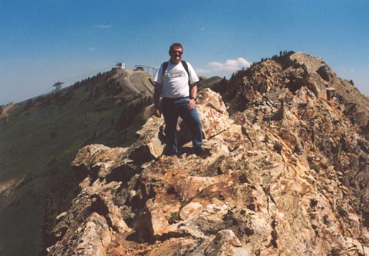
2004 Update: Climbed American Fork Twin Peaks for the second time. This time I took the ridge from the top of Hidden Peak, accessable from Alta or Snowbird. A trail leads down Hidden Peak onto this narrow ridge, and soon turns into exposed scrambling. The trickiest parts are on the reddish rock, including one spot that comes to a perfect point (knife edge). The intimidating black rock ahead turns out to be not as steep as it appeared, though you will still need to do some careful routefinding, and getting off the ridge much can lead to dangerously loose rock. We thought we'd have it made in the shade once past the black rock, but the white rock above that was no treat...slippery and steep! A faint trail leads through it, onto the summit of the East American Twin.
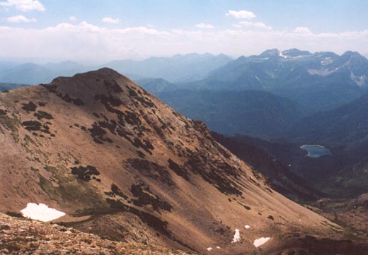
From the east twin, I headed south across open tundra to the south peak, since I had never been there. From this peak, you have a slightly better view south towards Mt. Timpanogos. On the way back towards the main peaks, a tremendous gust of wind blew my precious Miami hat off, but fortunately it went the way of the gentle slopes, instead of off a cliff! I crossed the ridge to the west peak, taking in the incredible views back down to Gad Valley and Snowbird, where several patches of snow still remained. Allen was already atop the peak, and we signed the log, and were soon greeted by three other climbers. We continued west to Red Top, taking in the great views back to the west twin peak, which is very under-rated amongst high Wasatch peaks for overall scenery. Our plan was to take Red Top's north ridge back down to Snowbird (the route I climbed in 1996), but this turned out to be tougher than I had remembered, as it wasn't all just easy tundra, but several sections of rock scrambling and bushwhacking on narrow ridges. A steep climb took us down to the service roads, where I took us on a wrong turn, adding yet another extra 30 minutes to the hike.