Bountiful Peak
Elevation: 9,259
Location: Wasatch Range, Utah
 Bountiful Peak is one of the more prominent Wasatch peaks in Davis County. From downtown
Bountiful the peak is obvious to the north with is double peaked summit. The left being
more pointed, and the right being flat. The peak however is really closer to the city
of Centerville. Access to the peak is easy from the Skyline Drive/Farmington Canyon
road which passes just about 100 feet below the peak.
Bountiful Peak is one of the more prominent Wasatch peaks in Davis County. From downtown
Bountiful the peak is obvious to the north with is double peaked summit. The left being
more pointed, and the right being flat. The peak however is really closer to the city
of Centerville. Access to the peak is easy from the Skyline Drive/Farmington Canyon
road which passes just about 100 feet below the peak.
The most popular way to climb the peak from the valley is via Parrish Creek in Centerville.
I have only hiked this trail once in early spring. It is a nice trail, steep at the beginning
as it switchbacks up a hillside not far from the prominent "V" on the mountain for a nearby
high school. After zig-zagging up the hillside, the trail levels out in a pleasant meadow as
the high peaks of the ridge become clear. Due to spring snow, I stopped here, but a trail
leads all the way up Parrish Creek to meet with Skyline Drive a few miles south of Bountiful
Peak, where you can follow the road, or the nearby ridge to the peak.
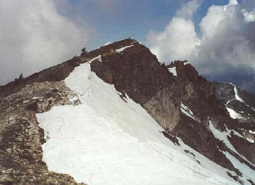
I prefer to climb the peak by driving up to the saddle at 8,100 feet on Skyline Drive, and
walk the ridge, or the road to the peak in spring when snow still fills the mountain. For
this hike, follow Skyline Drive up above the "B" for another local high school about six
miles to the obvious saddle. The road cuts off to the north for Bountiful Peak (and narrows).
You can walk this road directly towards the obvious summit. When the road gets near the
peak a tiny trail leads right up to the summit. When I climbed the peak in June of 1998
(after a hard winter), huge snow cornices still hung on the eastern slopes, and clouds from
a clearing storm were passing right by me. I walked the road much of the way, but it was
covered in snow mostly.
 I'm sure on a clear day that the view from Bountiful Peak is fantastic. The Great Salt Lake
sits far below, but on this cloudy day that was about all I could see. The trip from the
saddle to the peak is a mere climb of about 1,200 feet in three miles, and only takes about
three hours round trip. Following the ridgeline (when the cornices are not as big) is a
more enjoyable option with more elevation gain for extra ups and downs. The ridge is not
particularly rugged. It is an area much like Francis Peak offering good terrain for snow
climbing practice early in the year. The sunsets from the Wasatch in this area can be
spectacular with the sun setting behind Antelope Island and the Great Salt Lake.
I'm sure on a clear day that the view from Bountiful Peak is fantastic. The Great Salt Lake
sits far below, but on this cloudy day that was about all I could see. The trip from the
saddle to the peak is a mere climb of about 1,200 feet in three miles, and only takes about
three hours round trip. Following the ridgeline (when the cornices are not as big) is a
more enjoyable option with more elevation gain for extra ups and downs. The ridge is not
particularly rugged. It is an area much like Francis Peak offering good terrain for snow
climbing practice early in the year. The sunsets from the Wasatch in this area can be
spectacular with the sun setting behind Antelope Island and the Great Salt Lake.
From Skyline Drive, Bountiful Peak is surely one of the easiest peaks to attain in the Wasatch.
The route up from Parrish Creek is much more challenging in it's climb of over 4,000 feet to
the summit. If you climb from that way, be sure not to miss the sign on the west side of the
road marking the trail heading back down into Parrish Creek. In summer, the lower elevations
make this hike less pleasant.
2001 Update: Ascended Bountiful Peak on May 19th by walking the road from
the parking lot at about 8,100 feet on Skyline Drive above Bountiful. One of my goals on
this, my second ascent of Bountiful Peak was to get a picture of Francis Peak from it's summit
as clouds obscurred the view on my 1998 climb. As I neared the summit of Bountiful Peak clouds
were rapidly growing above me. Soon small, wispy clouds were coming up the canyons below, racing
over my head and into the sky, a beautiful, if somewhat un-nerving experience. When reaching the
ridge just below the summit I got my view of Francis, again, walled in by clouds.
 I walked the easy trail about 150 feet from the road to the peak. The view back down into the Morgan
area is beautiful, and I enjoyed a good view south towards Sessions Mountain, Grandview Peak's tiny
pyramid and the Salt Lake mountains far in the distance. A short walk took me to the flat, slightly
lower sub-peak. I highly reccomend this short trip as it gives a good view of the rugged backside
of Bountiful Peak (which appears so tame from the Davis County side). I walked back to the peak and
down to the road (in spring it is covered by a major snowfield here). I waited patiently for about
45 minutes, but the clouds finally lifted giving me a brief glimpse of Francis Peak's white radar
domes. Easy walk back down the road about 3.25 miles to the parking. Quality road, had no problems
getting my passenger car to the trailhead. One of the best spring hikes in the area.
I walked the easy trail about 150 feet from the road to the peak. The view back down into the Morgan
area is beautiful, and I enjoyed a good view south towards Sessions Mountain, Grandview Peak's tiny
pyramid and the Salt Lake mountains far in the distance. A short walk took me to the flat, slightly
lower sub-peak. I highly reccomend this short trip as it gives a good view of the rugged backside
of Bountiful Peak (which appears so tame from the Davis County side). I walked back to the peak and
down to the road (in spring it is covered by a major snowfield here). I waited patiently for about
45 minutes, but the clouds finally lifted giving me a brief glimpse of Francis Peak's white radar
domes. Easy walk back down the road about 3.25 miles to the parking. Quality road, had no problems
getting my passenger car to the trailhead. One of the best spring hikes in the area.