Cascade Mountain
Elevation: 10,908
High Point: 10,761 on south summit
Location: Wasatch Range, Utah
 Cascade Mountain is the next major mountain south of Timpanogos, directly south of Provo Canyon, and
the home of Bridal Veil Falls. It is a difficult mountain compared with most others in the Wasatch and only a
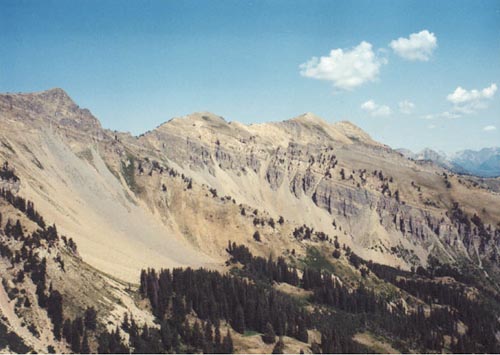
few diehard peak-baggers seem to even pursue this peak. The mountain has four "peaks" along it's long
summit ridge, with the high point being a 10,908 foot peak on the northern part of the ridge. The northernmost
peak is 10,874, with another middle peak of 10,680+ just south of the main summit. The southern peak, where I would stop is 10,761.
Cascade Mountain is the next major mountain south of Timpanogos, directly south of Provo Canyon, and
the home of Bridal Veil Falls. It is a difficult mountain compared with most others in the Wasatch and only a
few diehard peak-baggers seem to even pursue this peak. The mountain has four "peaks" along it's long
summit ridge, with the high point being a 10,908 foot peak on the northern part of the ridge. The northernmost
peak is 10,874, with another middle peak of 10,680+ just south of the main summit. The southern peak, where I would stop is 10,761.
After studying maps and books, the best route I had come up with for Cascade was to drive to the trailhead
just past Rock Creek Campground and hike up Dry Fork. The Squaw Peak road is well-graded to the Rock Creek
Campground, but beyond here it is very rocky for another half mile to the trailhead. This would give me access to the mountain's southeast
ridge, which can be taken to the summit according to Gary Nichols' book. In 2001 I hiked up this trail to a
10,125 foot sub-peak offering a great view of the mountain. It is obvious from here (as well as talking to other
hikers) that the crux of the climb
is the ascent up to the southern peak. The hike up Dry Fork was very nice, and a great example of
some of the under-rated hikes that can be found in the high peaks of Utah County...seems many people just
don't look for anything besides Timpanogos. A long switchback near the top leads into a pretty cirque under
an un-named 10,801 foot triangular peak before turning back and leading to the saddle, where the trail meets
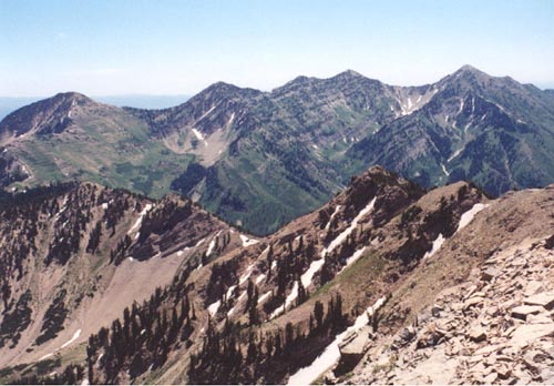
with the Big Springs Hollow/Shingle Mill trail from the east (a longer hike). From the saddle and the ridge towards
Cascade, the views back of the Provo Peak area are amazing, and a climb of Provo Peak from this ridge looks
most appealing.
 Forward to 2002, and my attempt at Cascade. The Wasatch Mountain Club was doing this hike from the
same route that I was seeking, so it seemed an obvious choice to go with them, rather than try the rugged
peak on my own. In hind-sight I was overmatched by this peak right now...despite several hikes this spring, a
long-lasting cold in early June had me still nowhere near 100% at the time we did the hike, and that would
keep me from the true summit. Nevertheless, it was an outstanding day of hiking and scrambling.
Forward to 2002, and my attempt at Cascade. The Wasatch Mountain Club was doing this hike from the
same route that I was seeking, so it seemed an obvious choice to go with them, rather than try the rugged
peak on my own. In hind-sight I was overmatched by this peak right now...despite several hikes this spring, a
long-lasting cold in early June had me still nowhere near 100% at the time we did the hike, and that would
keep me from the true summit. Nevertheless, it was an outstanding day of hiking and scrambling.
Besides myself, the hike included two other guys, Don and Chad, who was the leader. We began hiking up the trail and quickly
I could see I simply wasn't as quick as they were, but I was still hopeful that I could get into a groove and
still get to the summit as the day went on. After about two miles of hiking up Dry Fork, a little before the
big switchback they opted to leave the trail and ascend directly up a steep brushy hillside to the Cascade ridge
near peak 10,125. The hillside was steep and quite taxing to climb. In hindsight, I would have rather stayed on
the more gradual trail and not exhausted myself so quickly. Nevertheless, we reached the ridge, took a short break and began to proceed
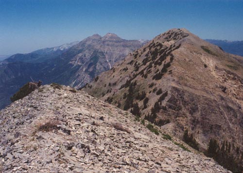
across several minor peaks before beginning the scramble up to the southern peak. I was happy to see a faint path
across much of the terrain past the peak I had stopped on in 2001. Soon after this we saw a Bighorn Sheep scampering
around in the cliffs below us, my first ever sighting of one of these! Unfortunately I could not get my camera out
in time for a photo before it was gone. A few patches of snow lingered despite the incredibly hot June we have had in Utah.
 The faint path continued most of the way up to the southern summit, but it involved a lot of scree-climbing on steep
slopes with lots of loose rock and some moderate exposure in spots. Probably most annoying were the amount of scrub trees that required climbing
over, under and around on the narrow ridge. By the time we were approaching the south summit (a longer climb than it had
looked) I was feeling exhausted and I
could clearly see I was holding the two of them back. It was now 1pm and I looked ahead to the true summit still a good ways in the distance, and
the 300 foot drop and climb to the peak inbetween (peak 10,680+). Realizing that I'd have to climb that twice, I knew pushing myself further
could make the descent even more difficult, so I opted to stay on the south peak and let them continue to the main peak. Perhaps
most frustrating was that it seemed obvious that the worst of the terrain was behind me, and if I had more stamina, getting to
the main summit shouldn't have been too difficult. I waited on the south peak taking photos
and trying to rest up for the descent. After a while they returned having reached the peak. I could see a few other climbers on
the peak and they informed me they had come up from Bunnell's Fork, a more direct route, but with a lot of vertical gain (over 5,000 feet).
The faint path continued most of the way up to the southern summit, but it involved a lot of scree-climbing on steep
slopes with lots of loose rock and some moderate exposure in spots. Probably most annoying were the amount of scrub trees that required climbing
over, under and around on the narrow ridge. By the time we were approaching the south summit (a longer climb than it had
looked) I was feeling exhausted and I
could clearly see I was holding the two of them back. It was now 1pm and I looked ahead to the true summit still a good ways in the distance, and
the 300 foot drop and climb to the peak inbetween (peak 10,680+). Realizing that I'd have to climb that twice, I knew pushing myself further
could make the descent even more difficult, so I opted to stay on the south peak and let them continue to the main peak. Perhaps
most frustrating was that it seemed obvious that the worst of the terrain was behind me, and if I had more stamina, getting to
the main summit shouldn't have been too difficult. I waited on the south peak taking photos
and trying to rest up for the descent. After a while they returned having reached the peak. I could see a few other climbers on
the peak and they informed me they had come up from Bunnell's Fork, a more direct route, but with a lot of vertical gain (over 5,000 feet).
The trip down was tricky as I was still wobbly and slow. A snowbank along the way made for a nice rest to get some cold water and cool off
on this hot day. As we got lower, they again opted to descend straight down the hillside rather than taking
the trail. I wasn't too thrilled with this choice as I've never been a fan of beating a track up or down a mountain where
a perfectly good trail already exists, even if it does take a bit longer. We arrived back at the trailhead just after 7pm making for an 11 hour day of
climbing. We all agreed it was tougher than we had anticipated. I have no idea if and when I'll make another attempt at Cascade, although I'm now considering a hike up Bunnell's Fork just
to explore that canyon. I'm wondering if that ridge makes for a better ascent route(steeper, but much shorter distance than this long ridge). Regardless
of route taken, I would certainly say that Cascade deserves some mention when discussing the most difficult peaks of the Wasatch range.