Clayton Peak
Elevation: 10,721
Location: Wasatch Range, Utah
 Clayton Peak is one of those easily climbed peaks in the Brighton area.
You can drive to the 8,700 foot parking lot and climb the 2,000 feet
to it's summit (all trail) and be back within a couple of hours. The peak can also be climbed
via Guardsman Pass and Clayton's north ridge. From here it is a short, but steep hike.
Clayton Peak is one of those easily climbed peaks in the Brighton area.
You can drive to the 8,700 foot parking lot and climb the 2,000 feet
to it's summit (all trail) and be back within a couple of hours. The peak can also be climbed
via Guardsman Pass and Clayton's north ridge. From here it is a short, but steep hike.
From the Brighton parking lot, the route to Clayton requires hiking the
Lake Mary trail most of the way to the lake. Near Dog Lake, a trail
branches east towards Snake Creek Pass. Another trail exists that
branches off earlier. Both routes are easy, enjoyable hikes. Brighton
ski area, much like others in the area, is constantly changing and
the best route to the pass may change. Consult the most up to date
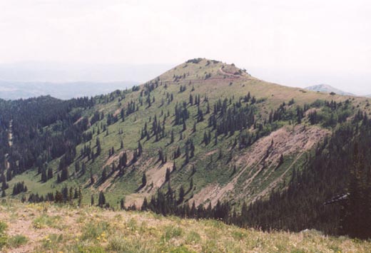
books or maps. Much of the way, Clayton Peak will be clearly visible.
From the pass at just over 10,000 feet you'll have a good view back to
the south towards Mount Timpanogos. You'll see a trail branching to
the right that switchbacks up the slopes of Clayton some 700 feet
above. Follow this trail, which gets a little rocky at the end up
to the peak.
 Below the peak you'll see tiny Lackawaxen Lake, and the Heber area
far off in the distance. Across the Brighton resort you'll clearly
see the peaks near Mount Wolverine. Atop the peak is a mailbox wedged
into the rocks where you can write about your summit experience.
The distance to the peak from either of these routes is roughly 2.5 miles. The trip back is short and sweet. Clayton is not one of the more
exciting Wasatch summits, but like Sunset Peak, a fairly high peak
that can be attained with minimal effort.
Below the peak you'll see tiny Lackawaxen Lake, and the Heber area
far off in the distance. Across the Brighton resort you'll clearly
see the peaks near Mount Wolverine. Atop the peak is a mailbox wedged
into the rocks where you can write about your summit experience.
The distance to the peak from either of these routes is roughly 2.5 miles. The trip back is short and sweet. Clayton is not one of the more
exciting Wasatch summits, but like Sunset Peak, a fairly high peak
that can be attained with minimal effort.
2003 Update: Looking for fairly easy climbs to get back into the swing of things, I opted to try Clayton via
the north ridge, a route I had not done before. Because the hike is so short (about 1.5 miles each way
from Guardsman Pass, climbing a little over 1,000 feet), I opted to extend the trip to climb nearby
Jupiter Peak (elev. 9,998), one of the prominent peaks over the Park City area. I was going to try
nearby Scott Hill, but the extreme heat and my lack of conditioning this year didn't allow for that.
I have done the standard Brighton route up Clayton multiple times and generally find it to be an unspectacular
hike. I found the north ridge to be far more to my liking. The hike starts at Guardsman Pass (elev. 9,700) above
Big Cottonwood Canyon. I had not been up this road in years, and much to my surprise it is now paved all the
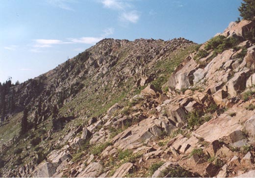
way to the pass via Big Cottonwood. From the pass an obvious trail leads steeply up Clayton's north ridge
to just below a false summit (elev. 10,420) on the west side. The trail is faint as it bypasses this peak, and then
re-appears as you descend 200 feet to the saddle between these peaks. The views southwest of Timpanogos and the high
Cottonwood Canyon peaks is wonderful. To the east several small lakes can be seen on the Park City side. The trail climbs
steeply again as it ascends to Clayton's rocky summit. Near the top the trail fades into the rocks and some easy boulder
hopping is required. Having started so early to beat the heat, I found myself alone on the summit and signed the register
in the mailbox, which has somehow managed to survive this easily and often climbed peak.
 After descending the steep trail back to Guardsman Pass I decided to try nearby Jupiter Peak. I originally planned
to take the steep trail directly north of the pass to the ridge to an un-named 10,026 foot peak. However after the already
steep ascent/descent of Clayton, I took a gentler route by descending the gravel road from Guardsman to the east for about .2 miles and
taking a jeep track that lead north back to the main ridge where I simply continued east to the somewhat unspectacular summit of
Jupiter Peak. This open, rounded ridge felt much more like the peaks of Davis County than the much rougher Cottonwood peaks
nearby. There was a fine view and steep drop into Park City, and the small emergency hut just south of the peak made for
a nice place to take a rest. I descended west across the ridge past the 10,026 foot peak in hopes of climbing Scott Hill, but tired and
hot I caught onto a road that bent back around to Guardsman Pass and called it a day.
After descending the steep trail back to Guardsman Pass I decided to try nearby Jupiter Peak. I originally planned
to take the steep trail directly north of the pass to the ridge to an un-named 10,026 foot peak. However after the already
steep ascent/descent of Clayton, I took a gentler route by descending the gravel road from Guardsman to the east for about .2 miles and
taking a jeep track that lead north back to the main ridge where I simply continued east to the somewhat unspectacular summit of
Jupiter Peak. This open, rounded ridge felt much more like the peaks of Davis County than the much rougher Cottonwood peaks
nearby. There was a fine view and steep drop into Park City, and the small emergency hut just south of the peak made for
a nice place to take a rest. I descended west across the ridge past the 10,026 foot peak in hopes of climbing Scott Hill, but tired and
hot I caught onto a road that bent back around to Guardsman Pass and called it a day.