Hayden Peak
Elevation: 12,479
Location: Uinta Range, Utah
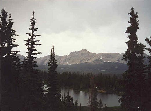 Hayden Peak is a rugged and scenic peak located very near to the popular Mirror Lake
area along Highway 150. There is an overlook along the road which offers a spectacular
view of the peak. I climbed Hayden with the Wasatch Mountain Club as the peak had a reputation
that kept me from wanting to attempt it solo. We had a large, but fun and outstanding group on
this day. Not all pictures are back from this hike yet...keep posted.
Hayden Peak is a rugged and scenic peak located very near to the popular Mirror Lake
area along Highway 150. There is an overlook along the road which offers a spectacular
view of the peak. I climbed Hayden with the Wasatch Mountain Club as the peak had a reputation
that kept me from wanting to attempt it solo. We had a large, but fun and outstanding group on
this day. Not all pictures are back from this hike yet...keep posted.
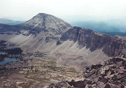
The most common route up Hayden begins at the Highline trailhead at about 10,300 feet, but it doesn't really
use that trail at all. You should be able to see a spur ridge leading down from the main
Hayden/Agassiz ridge. If you can generally stay on this ridge you'll have the best route. At
first the hiking is easy travel up gentle, forested slopes. A small cliffband is quickly encountered
that can by easily bypassed if you take a minute to check around for a safer route. A faint track
will lead you higher where the much larger cliffs await. You should be able to see a bend in the
main cliffband from far below, aim for that, climbing over the boulders.
 When you get to the bend what you find is a challenging 10-15 foot crack requiring use of all
four limbs. It isn't as bad as it looks (until the trip down!), and beyond this the terrain eases
up as you approach the ridge, but is still fairly tedious, slow travel.
When you get to the bend what you find is a challenging 10-15 foot crack requiring use of all
four limbs. It isn't as bad as it looks (until the trip down!), and beyond this the terrain eases
up as you approach the ridge, but is still fairly tedious, slow travel.
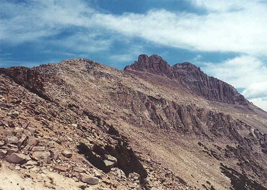
The ridge is at about 11,700 feet. McPheters Lake and Ryder Lake appear to the east. Continuing on
the ridge towards the peak is gentle boulder-hopping for a while. Be sure to take a look back towards
Mirror Lake and the Bald Mountain/Reids Peak area. On this day a wildfire was burning to the south, making
for subpar views, but still outstanding. The terrain steepens as you approach the first peak, which is
not the high point. A chute of loose rock to the left leads you around the rugged cone to terrain that
is suitable for scrambling to the notch between this first peak and the true summit of Hayden. There is
a great deal of exposure and loose rocks in this area, so proceed carefully.
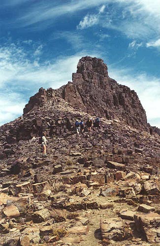 From this notch between the peaks you'll find the best terrain to now be on the right (or east) side
of the mountain. It is still rugged and full of loose rock. You'll need to go north around most of the
east side of the summit pyramid to find the best passage to the peak. The views are outstanding, rewarding
you for your efforts in climbing this short but treacherous mountain. Along the ridge to the south is 12,428 foot
Mt. Agassiz. Bald Mountain (11,949 feet) and Reids Peak sit across Mirror Lake to the west (with the high peaks of
the Wasatch visible in the distance). Following the ridge north from Hayden Peak leads to Kletting Peak, with A-1 Peak jutting
to the east. Ostler and Spread Eagle Peak sit to the east across Stillwater Fork. Afternoon thunderstorms are very
common in the Uintas, and this is not a peak to be caught on in a lightning storm, so keep your eyes open
for that.
From this notch between the peaks you'll find the best terrain to now be on the right (or east) side
of the mountain. It is still rugged and full of loose rock. You'll need to go north around most of the
east side of the summit pyramid to find the best passage to the peak. The views are outstanding, rewarding
you for your efforts in climbing this short but treacherous mountain. Along the ridge to the south is 12,428 foot
Mt. Agassiz. Bald Mountain (11,949 feet) and Reids Peak sit across Mirror Lake to the west (with the high peaks of
the Wasatch visible in the distance). Following the ridge north from Hayden Peak leads to Kletting Peak, with A-1 Peak jutting
to the east. Ostler and Spread Eagle Peak sit to the east across Stillwater Fork. Afternoon thunderstorms are very
common in the Uintas, and this is not a peak to be caught on in a lightning storm, so keep your eyes open
for that.
As you can imagine the trip down Hayden requires careful downclimbing of all the same spots you came up. Steep, loose
rocks are even easier to knock loose or slip on while going down. I would personally avoid temptation to climb
down the steep scree gullies on the mountain north of the ridge used for ascent. One member of our group was crossing
one of these gullies when a large rock he was hanging onto came loose, sending him and the rock downward. He took a 20 foot
tumble narrowly missing getting hit by the rock, which cascaded hundreds of feet down the mountainside. He took a fairly
severe head injury, as well as neck and back injuries. Fortunately our hike leader was a nurse/EMT and another hiker had
a cell phone. We had no option other than to call for help, which came in the form
of a life flight helicopter. After over an hour the hiker was picked up and swept away (with a wave to us, which was very
encouraging). It is a reminder of how dangerous scrambling such as this can be. This hiker was someone who I would say
was a better climber than me, so nobody is immune to these dangers.
 I must admit the descent was difficult after seeing the accident, but regardless one should descend this rugged
peak with care. Be sure to orient yourself so you end up at least near the Highline trailhead. Remember there are a few
hidden cliffbands along the way down, even near the end. Hayden is a great climb for the hiker who
enjoys difficult, exposed scrambling. Distance is about 2.5 miles to the peak, with about a 2,200 foot climb, however it
will feel like much further!
I must admit the descent was difficult after seeing the accident, but regardless one should descend this rugged
peak with care. Be sure to orient yourself so you end up at least near the Highline trailhead. Remember there are a few
hidden cliffbands along the way down, even near the end. Hayden is a great climb for the hiker who
enjoys difficult, exposed scrambling. Distance is about 2.5 miles to the peak, with about a 2,200 foot climb, however it
will feel like much further!