Big Baldy
Elevation: 8,756
Location: Wasatch Range, Utah
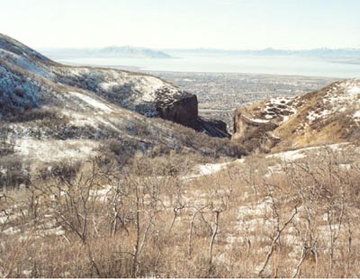 Mt. Timpanogos has several smaller peaks on it's western flank, and Big Baldy, at 8,756 feet is probably
the most popular. It is a realtively easy climb from Dry Canyon, and in spring offers a close-up look
at Timp's massive west face still covered in snow.
Mt. Timpanogos has several smaller peaks on it's western flank, and Big Baldy, at 8,756 feet is probably
the most popular. It is a realtively easy climb from Dry Canyon, and in spring offers a close-up look
at Timp's massive west face still covered in snow.
The trail starts immediately by winding up thru some impressive limestone walls. The trail has undergone
some construction in spring of 2002 in this lower section, and the improved parts have been done very well. Once
you climb out of the cliffs the trail meanders into a meadow where Big Baldy's bland west slope becomes obvious. While
it looks wide open at first, closer inspection reveals some serious bushwacking thru scrub oak if you opt for the shorter, steeper
route up the peak. The trail continues up gently into Dry Canyon, and snow may linger into the summer in the canyon's bottom from
the large and powerful avalanches that run down the face of Timpanogos. Soon the trail begins a steep climb for well over a mile
to reach the ridge at 8,332 feet. The trail meets with the trail coming up from the north side of Big Baldy (Battle Creek-A nice hike
with a pretty waterfall in spring). From here Big Baldy is a 400 foot hike along the gently sloping ridge to the west.
In May of 2002, the ridge was still snow-covered, but it was not difficult to find my way to the summit. An alternative is
to take one of the many terraces on the mountain and work your way up the hillside to the peak. The views of Timp are impressive, even if
like on this day, clouds were obscuring most of the highest peaks. The roundtrip distance was about seven miles, with a climb of 3,600 feet, and will
probably take four to five hours of hiking time total. The views are nice, but not as nice as either Squaw or Y Mountain offer.
Squaw Peak
Elevation: 7,877
Location: Wasatch Range, Utah
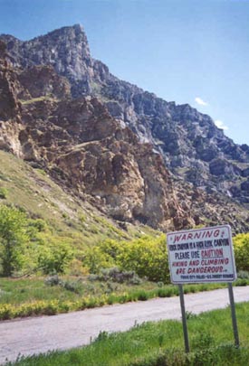 Perhaps the most popular smaller peak in Utah County is Squaw Peak, at the mouth of Rock Canyon (just above the Provo Temple and the Missionary Training Center). From the west you can see
Squaw gently rising from north to south, but the south side drops abruptly to the canyon bottom, creating a ferocious south face. Actually, either
side of Rock Canyon is quite rugged, and due to the popularity of the canyon, and the number of accidents here, the warning sign is valid.
Perhaps the most popular smaller peak in Utah County is Squaw Peak, at the mouth of Rock Canyon (just above the Provo Temple and the Missionary Training Center). From the west you can see
Squaw gently rising from north to south, but the south side drops abruptly to the canyon bottom, creating a ferocious south face. Actually, either
side of Rock Canyon is quite rugged, and due to the popularity of the canyon, and the number of accidents here, the warning sign is valid.
While Kelsey's book shows a route ascending the more rugged west side of Squaw (lots of steep, loose rock), a better alternative is the trail which
heads up Rock Canyon (which is paved for the first bit) past some rugged cliff walls on both sides with the stream rushing alongside the trail. The trail to Squaw crosses the stream to the left (north) and makes a lengthy trip north through thick forest before turning and heading back south up the gentle north
ridge of Squaw Peak (steepens at the very top). The most difficult part of the route is finding the trail that branches from the main Rock Canyon trail. This is quite a ways up the trail where the canyon opens up and gullies
can be seen both north and south. Assuming you find it, it is
a wonderful hike, especially in spring, with great views of rugged Cascade Mountain above. As you make your way to the north, you'll have a fine view of Mt. Timpanogos. The trail turns and
gets steeper as you finish the climb to the summit, where you are greeted with an impressive view back down to the Rock Canyon trailhead, nearly 3,000 feet straight down! You'll also have a great view up
higher into Rock Canyon with Provo Peak beyond, a seldom visited 11,000 foot peak. Directly south across Rock Canyon is the tremendously rugged north face of Y Mountain.
I did this hike with the Wasatch Mountain Club back in May of 1998 and encountered no snow.
 Taking this route up Squaw is approximately three miles each way, climbing about 3,000 feet total. Expect roundtrip hiking times of three to four hours. It is possible to hike up Rock Canyon as far as the Rock
Canyon Campground (elev. 6,550) and use this as access for an attempt at the much higher Cascade or Provo Peak, but this would be a very long and difficult all-day adventure for very serious hikers/scramblers only. Most attempts at these higher peaks start by driving
up the Squaw Peak road (easily driven in passenger cars up to Rock Canyon Campground), lessening the elevation gain to get to the peaks. Another trail branches right (south) well before the campground and leads over towards Slide Canyon, and the trail can be taken as
far as the next canyon south (Slate Canyon) and even to the Squaw Peak road further to the south. Further to the north is a smaller peak some locals refer to as "semi-Squaw", but I have no experience hiking in that area. The hike up Rock Canyon exposes some of the most rugged terrain in the
Wasatch, especially considering the lower elevation. In my hikes up this canyon I have often seen huge stands of trees smashed over from the large, powerful avalanches released from the steep slopes during
the winter.
Taking this route up Squaw is approximately three miles each way, climbing about 3,000 feet total. Expect roundtrip hiking times of three to four hours. It is possible to hike up Rock Canyon as far as the Rock
Canyon Campground (elev. 6,550) and use this as access for an attempt at the much higher Cascade or Provo Peak, but this would be a very long and difficult all-day adventure for very serious hikers/scramblers only. Most attempts at these higher peaks start by driving
up the Squaw Peak road (easily driven in passenger cars up to Rock Canyon Campground), lessening the elevation gain to get to the peaks. Another trail branches right (south) well before the campground and leads over towards Slide Canyon, and the trail can be taken as
far as the next canyon south (Slate Canyon) and even to the Squaw Peak road further to the south. Further to the north is a smaller peak some locals refer to as "semi-Squaw", but I have no experience hiking in that area. The hike up Rock Canyon exposes some of the most rugged terrain in the
Wasatch, especially considering the lower elevation. In my hikes up this canyon I have often seen huge stands of trees smashed over from the large, powerful avalanches released from the steep slopes during
the winter.
Y Mountain
Elevation: 8,568
Location: Wasatch Range, Utah
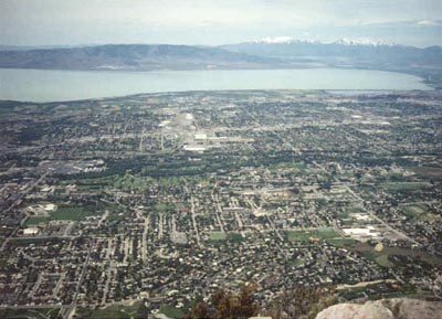
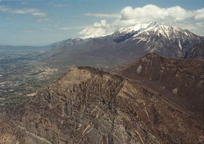 The Y Mountain hike is one of the better small peaks in the Wasatch. The summit views of nearby Mt. Timpanogos, Squaw Peak, Cascade
Peak and Provo Peak, with Mt. Nebo visible to the far south is one of the best summit views anywhere in the Wasatch range. The beauty of
the hike via Slide Canyon is that it is free of snow quite early in the year as most of the route is either facing west or south.
The Y Mountain hike is one of the better small peaks in the Wasatch. The summit views of nearby Mt. Timpanogos, Squaw Peak, Cascade
Peak and Provo Peak, with Mt. Nebo visible to the far south is one of the best summit views anywhere in the Wasatch range. The beauty of
the hike via Slide Canyon is that it is free of snow quite early in the year as most of the route is either facing west or south.
The hike begins by following the popular trail up to the infamous Y on the mountainside. It is a steep mile and 900 feet up a jeep road to this point, and
someone has measured the distance to the foot and written it on the trail markers along the way, so you can see your progress. The fire in the
summer of 2001 has torched many of the trees, particularly on the west side as far as I could tell. From the crowded Y, a much smaller trail heads south to
some neat rock formations (good for pictures of fellow hikers) and then turns east and ascends more gently into Slide Canyon. When I recently climbed this peak there
was only one other group that went beyond the Y, and they were not even from Utah! Following the scenic trail up Slide Canyon for a mile or so, you'll arrive at a small, angled
meadow. From here it is only about five minutes to the junction for Y Mountain. This junction is pretty obvious to most hikers, but not so obvious that everyone
will see it. Another mark to look for is a fallen aspen tree on the right side of the trail, at about a 45 degree angle propped on other trees. The Y junction is about
100 feet before this.
Follow the track up the wooded, steep hillside. It is still about 1,000 feet to Y's dual summits. The track stays basically in the dry streambed. As you climb higher the angle
starts to ease, and the forest opens up. Behind you is a great view of Maple Mountain and part of Provo Peak to the east. Eventually the slope becomes almost flat as you arrive
at the saddle, at about 8,400 feet. The best views to the north are pretty much blocked by trees. I found a good track to the lower, west peak. This peak had the best view
of the valley below, but the rest of the view was somewhat obscured by the trees or the higher east summit. After a quick descent back to the saddle, it was only about 10-15 minutes
to the eastern peak. Here you are greeted with a stunning 180 degree view from Lone Peak in the north to Mt. Nebo to the south, with Timpanogos, Squaw, Cascade, Provo Peaks inbetween, all looking
spectacular. A large eagle swooped overhead as I sat alone on the summit for 30 minutes admiring the snowcapped peaks above (and surveying my future route up Cascade later this summer).
The roundtrip for this climb of Y Mountain is seven miles, with a climb of roughly 3,500 feet. Expect three to five hours for the roundtrip, and make sure to bring
a camera for the views from the east summit!