Mount Millicent
Elevation: 10,452
Location: Wasatch Range, Utah
Mount Millicent is a fairly quick and easy climb in the Brighton ski
area. So quick in fact that I climbed it in the evening after a day
of work in August of 1997 to watch the sunset.
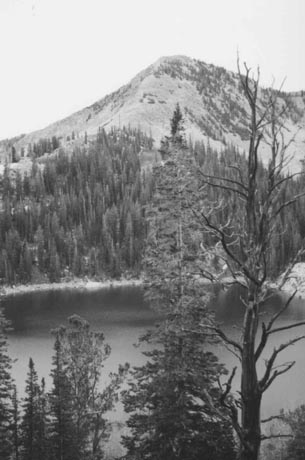 The hike starts from the Silver Lake area as you enter Brighton. Follow
the boardwalk around the lake to the trail. Along this boardwalk you'll
have a clear view to Mount Millicent towering above Silver Lake. It quickly branches left to
go to Twin Lakes, follow this trail as the trail continuing straight
leads to tiny Lake Solitude. The hike to Twin Lakes is short, fairly
steep in spots, but quick. It is only a mile and a little over 700 feet
to Twin Lakes.
The hike starts from the Silver Lake area as you enter Brighton. Follow
the boardwalk around the lake to the trail. Along this boardwalk you'll
have a clear view to Mount Millicent towering above Silver Lake. It quickly branches left to
go to Twin Lakes, follow this trail as the trail continuing straight
leads to tiny Lake Solitude. The hike to Twin Lakes is short, fairly
steep in spots, but quick. It is only a mile and a little over 700 feet
to Twin Lakes.
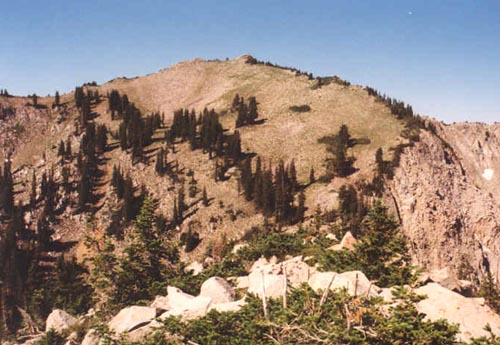
From Twin Lakes you'll have a clear view of the Mount Wolverine cirque
and Mount Millicent on the northern end of the ridge, a few hundred feet
lower. Millicent appears as nothing more than a steep pile of boulders.
To get to it follow the ski road below the Twin Lakes dam and ascend
the obvious road going up the slopes of Millicent up to a little over
9,800 feet. From here you'll have 600 feet of boulders to climb up
to the summit.
The climb is tedious over the large boulders, and be careful of loose
rocks so you don't get your foot rolled over. From the summit you'll
have a good view into the Wolverine Cirque and back down towards Twin
Lakes and the route you came up from. The evening light was beautiful,
but I would find out later that the film in my camera had not been wound
properly and I never got any pictures from this hike (or the Mount
Superior hike of that same year).
I plan to return in 2001 and to a three peak loop hike by hiking up to
Twin Lakes Pass, ascending Honeycomb Cliffs, returning to the pass and climbing
the west ridge to Mount Wolverine, and following the ridge down to Millicent
and back to Twin Lakes. Options for multi-peak trips are endless in the
Brighton area!
The trip back down the boulders was slow but tolerable, and I was back
to the trailhead quickly before it got too dark. Roundtrip was about four
miles, climbing a little over 1,700 feet. Expect a climb of just Millicent
to take about two to three hours, but much longer if you start adding
multiple peaks.
 2002 Update: Returned to Millicent in hopes of getting some pictures since
I lost mine from my first ascent, and also to do the short ridge between Millicent and
Mount Wolverine. I met up with Julie from the Wasatch Mountain Club, who was leading a
similar hike the next day, and wanted to scout out the area. We quickly hiked the popular
trail from Brighton's Silver Lake to Twin Lakes. From here, we dropped just below the dam along
a ski maintenance road that winds it's way up closer to Mt. Millicent and the top of the
Millicent ski lift. From here it is about a 600 foot climb up large talus blocks (surprisingly stable by
Wasatch standards) to the top of Millicent.
2002 Update: Returned to Millicent in hopes of getting some pictures since
I lost mine from my first ascent, and also to do the short ridge between Millicent and
Mount Wolverine. I met up with Julie from the Wasatch Mountain Club, who was leading a
similar hike the next day, and wanted to scout out the area. We quickly hiked the popular
trail from Brighton's Silver Lake to Twin Lakes. From here, we dropped just below the dam along
a ski maintenance road that winds it's way up closer to Mt. Millicent and the top of the
Millicent ski lift. From here it is about a 600 foot climb up large talus blocks (surprisingly stable by
Wasatch standards) to the top of Millicent.
From the summit you have a fine view of much of the Brighton area, including Mount Wolverine straight ahead.
The west side of Wolverine drops sharply into rugged Wolverine Cirque, but the east side is mostly gentle
tundra. Before getting to Wolverine, you'll have to drop 200 feet down mixed talus and tundra before beginning
the 500 foot climb up the tundra (easy walking) to Wolverine's summit. Some small but pretty flowers lined
the hillside as we climbed. After a short stay, we took the trail down towards Twin Lakes Pass around Wolverine
Cirque. I had hoped to bag nearby Mt. Evergreen, but the heat was rising (A Salt Lake record was set this day of
107 degrees) and I opted to pass and get that one another time.