
Mount Nebo is the highest, and southernmost peak in the Wasatch Range. It is a mountain of three main peaks, north, middle, and south Nebo. Original surveys labeled the south peak as the highest (11,877 feet), but more recent surveys in the late 70's corrected this to show the north peak as 51 feet higher. Unfortunately by now, a good trail existed all the way to the south peak's summit. I'm sure a number of climbers have reached the wrong summit. From I-15 near Mona, the peak towers above the road in neck-bending fashion.
In 1994 I made a trip with my dad to attempt the north peak via the highpoint of the Nebo Scenic Loop road at Monument trailhead (about 9,250 feet). From here I would follow the Nebo Bench trail for about two miles and cut off up a side canyon that led directly to "Wolf Pass" between the north summit of Nebo, and nearby "North Peak"...don't confuse those two.
The trail immediately descends, which of course you need to reclimb, but most of the first two miles of trail is flat, and you'll probably encounter a number of cows. You'll have to keep an eye out for this canyon, and consult your topo maps to keep track when you get to the right drainage. A newer route now exists for the north peak of Nebo, check out more recent guidebooks for this easier route. After finding the drainage, a climb of about 1,200 feet is required to reach Wolf Pass above.
This off-trail climb begins by hacking through some unpleasant scrub trees, that leave thorny brambles in your pants or shoes. I was glad I wore sweats on this day instead of shorts. On the way down I found a more friendly route through rocks. Follow the drainage up, it's not too steep, but still taxing. Near the ridge it gets a little more steep and rocky, but still nothing overly difficult, and could barely be described as "scrambling".
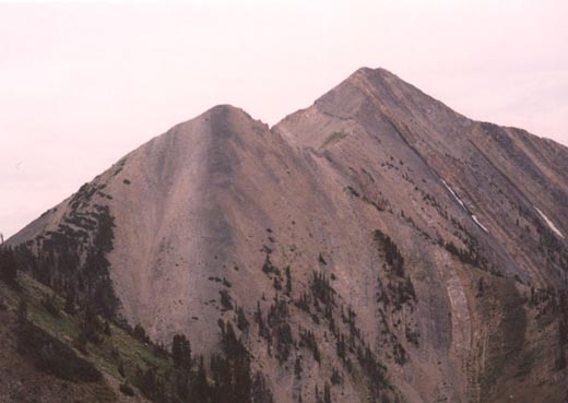
Once on the ridge a trail appears, and you can follow it 800 feet up the bland peak to the south. From this final sub-peak, you'll have a great view of the pyramid of north Nebo. The peak looks pretty menacing, but the track can be followed all the way to the summit up the steep, rocky slope.

On this day there were about a half dozen other hikers making the trip by various routes to the highest peak in the range. Fires burning nearby filled the skies with smoke, limiting the views. It didn't help that the temperature in the valley was well over 100 degrees on this day. To the south was middle Nebo, and behind that south Nebo, which from here looked to be possibly higher. Of course, from south Nebo, the north peak looks clearly higher. The view back down to Mona is a drop of well over 7,000 feet vertical in one abrubt step. I enjoyed my stay on the highest peak in the range for a while and decided with my dad waiting below I'd better head down.
My trip down was adventurous. My dad had stayed behind far lower, and somewhere back on the Nebo Bench trail I took a wrong turn on the trails made by the cattle. I spent a good hour or so off the route, now dehydrated and out of water on this hot day. Resting seemed to do nothing to re-energize me. Fortunately I found my way back to the trail after downclimbing a steep hillside. I could see my dad wandering about looking for me. I was glad he'd decided to come on this day as the dehydration would've made driving the 90 miles back to Salt Lake nearly impossible. By now I could hardly walk the remainder of the trail out.

In 1998 after a failed attempt on California's Mount Whitney I opted to try the trail leading to south Nebo, Andrews Ridge. This long and steep trail is an all day affair, and with the hour and a half drive from the city each way, get an early start!!
The hike up Andrews Ridge is marked and the trail starts out plenty steep. The sun beats down on most of this hike also, so bring sunblock. A steep climb to a ridge and the trail levels out and heads north before another series of climbs back to the main Nebo ridge (now about 10,000 feet). Along the way you'll see the triple peaks of Nebo far above. At this ridge you'll meet a trail that comes up from the west side of the mountain, and nearby the Nebo Bench trail also joins the ridge.
From here, a sign marks the summit as two miles away. Start puffing up the gradually more open slopes. Eventually you'll have a clear view of the barren dome of south Nebo and the faint track leading to the peak.

Keep chugging up the relentless trail. The higher altitude will also help in wearing you down. This is a climb of nearly 5,500 feet so come prepared for an all day war. Until I climbed Mount Whitney a year later, this was the hardest "trail" hike I'd ever done. Soon you'll find a huge, rocky open area just a few hundred feet below the summit. It would be an ideal campsite on days when the wind is not blowing too stiff across the ridge.
Keep pushing up the final few hundred feet of rocky trail to the summit. Immediately the view to the north reveals middle and north Nebo. Many people climb to the highest Nebo peak by climbing south Nebo, then traversing the rugged ridge over middle Nebo, then to north Nebo. As tiring as the hike to south Nebo is, don't even consider this unless the weather is good and you have excellent stamina and minimal fear of heights.

On my 1998 climb I had much better weather conditions than in '94. The temperature was much cooler, and skies were crystal clear. Far to the north was Utah Valley and Mount Timpanogos. I ended up hiking most of the way down with two other solo hikers I'd met on the summit, one a man from Delta, and the other, a girl from Brigham Young University.
The hike down is a long one, and takes about four hours. With the steepness of the hike your knees will surely be aching by the time you get back to your car. Distance for Andrews Ridge is about 12 miles roundtrip with that 5,500 foot gain. My route to north Nebo from Monument trailhead I estimated at about 8 miles roundtrip, gaining around 3,000 feet with the extra ups and downs.
Nebo is a wonderful mountain, and any even remotely serious hiker in Utah should climb the peak, namely the lower but more scenic south Peak, at least once. It's not quite as scenic as Timpanogos, but far less crowded.
2003 Update: Since it had been nearly ten years since I climbed North Nebo I figured that would be a good goal in 2003, and I originally had hoped to take a shot at the summit of "Middle Nebo", which at 11,824 feet is the highest point in the Wasatch that I have never been to, behind both North and South Nebo. After much corrispondence over the past year I met up with Lane, Brent, Bart and Mike of www.lanep.org (an outstanding site) for an attempt on the relatively new trail that ascends North Nebo via the Nebo Bench/Monument Trailhead.
We met up at 8:30 and drove the .7 miles of dirt road to the cattleguard/barb wire fence which marks the start of the trail. The trail ascends steeply alongside the barb wire fence with a good view of "North Peak" which is not to be confused with North Nebo. The summer monsoon was in full swing and we had cloud cover for most of the hike. Soon the fence turns south and the trail continues west over several minor ridges before beginning a steep ascent to the north ridge of North Peak. I think we were all surprised with the good quality of this trail which few people seem to know about. Weibel and Miller's "High In Utah" book fails to even mention this trail which is far easier and safer to ascend the Utah County highpoint as opposed to the Andrews Ridge/Ridge scramble route.
Once we reached the ridge of North Peak we had a commanding view down to the valley below, Bald Mountain to the north and North Nebo's impressive pyramid to the south. Our elevation here was about 10,600 feet. The trail continues south climbing gradually around North Peak, then dropping to reach "Wolf Pass" at 10,600 feet. All along the way the remaining route up Nebo is obvious. You must first ascend the 11,460 foot sub-peak, then tackle the final summit cone. We took a rest at the pass as the clouds continued to grow all around. I was admittedly nervous already from the clouds (bad lightning experience in '95 on Mt. Elbert, and a newborn baby at home being the cause), but continued upwards. As we continued up the sub-peak the rain started to fall and it seemed a particularly dark cloud was headed right for us. While there was no lightning in sight I was admittedly jittery and having climbed the peak before, turned back at the sub-peak while the other guys continued to the summit.
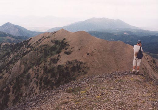
I hurried back down to Wolf Pass as it continued to rain lightly, and as I continued back around the west flank of North Peak I noticed that, of course, the weather was clearing now! I was a little mad at myself for turning back since it obviously cleared enough for a safe summit, but there's nothing wrong with being cautious either. I enjoyed the time taking some pictures of the wonderful view of North Nebo from here. I contemplated an ascent of North Peak while I waited for the others to catch up but realized I'd missed my best opportunity as the south slopes (from Wolf Pass) are a far easier way to ascend the peak. Despite the lack of a summit, the hike was outstanding. The distance roundtrip from this route is nine miles, and the elevation gain about 3,300 feet due to several extra up's and down's. Our time was roughly 6.5 hours.
As for my goal to attain Middle Nebo, that will probably have to wait until next summer. Even in good weather my conditioning was still very lacking due to the two month lay off earlier this summer, and the two hour drive each way from my house doesn't help either!