Thurston Peak
Elevation: 9,706
Location: Wasatch Range, Utah
 Thurston is the highest peak in Davis and Morgan counties, and was unnamed until the early
1990's. Although most of the attention
is focused on it's southern neighbor Francis Peak, Thurston is the highest peak on
"Farmington Ridge", the high, narrow ridge that seperates Davis and Morgan counties. The peak was relatively unknown until
recently when "bagging" the highest peak in each county of the state became popular. Now
various books describe climbing this peak from the Francis Peak road. Those looking for more
of a challenge will prefer the Kays Creek/Great Western Trail route.
Thurston is the highest peak in Davis and Morgan counties, and was unnamed until the early
1990's. Although most of the attention
is focused on it's southern neighbor Francis Peak, Thurston is the highest peak on
"Farmington Ridge", the high, narrow ridge that seperates Davis and Morgan counties. The peak was relatively unknown until
recently when "bagging" the highest peak in each county of the state became popular. Now
various books describe climbing this peak from the Francis Peak road. Those looking for more
of a challenge will prefer the Kays Creek/Great Western Trail route.
Climbing Thurston is relatively easy by driving to the top of Francis Peak in summer or
early fall when the road is open all the way. From here, it is a four mile ridge walk of
ups and downs to get to Thurston. When I climbed the peak from this route in 1994 I had
just recovered from a month of fighting with mono, and it was the first peak of any real
substance I climbed after the illness. Snow lingers on the eastern slopes of this part
of the range into July, so expect to spend a fair amount of time in the snow. From Francis
a road follows close to the ridge for a while, and then turns into a trail, which can
be followed faintly all the way to Thurston.
In June, I'd say about half of our hike was in snow, and some of the snowfields had long
dropoffs. These were not of the lethal variety, but the kind that a slide would take a
while to re-climb. The summit is marked with a large plaque in honor of the guy for whom
the peak is named. It is certainly one of the nicest summit plaques I've seen. From the
peak you'll have a good view north towards the Mount Ogden/Snowbasin area, and Ben Lomond
and Willard lurking behind. South you'll see Francis and it's signature radar towers. You
may hear the roar of F-16's flying overhead from nearby Hill Air Force Base, and you'll be
able to clearly point that out from the peak. On a clear day you may be able to make out
Deseret Peak far off to the west behind the Oquirrhs. The roundtrip time for this hike was around four hours. The vertical climb was probably in
the range of 1,500 feet (maybe more).
 2003 Update: A longer route to climb Thurston exists by hiking up the Kays Creek Trail, which is part of the
Great Western Trail (beginning near an old castle) on a long and steep trail. I took this trail up to roughly 8,000
feet in late April where snow blocked the trail. The trail begins at the top of Fernwood Drive by climbing north past the castle
and down and around a couple of ridges, crossing a stream on a fine bridge, before beginning a steep
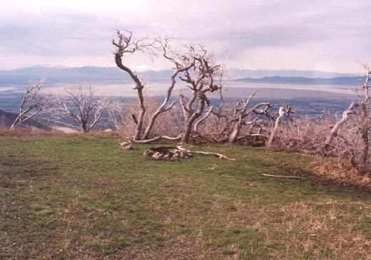
climb up the ridge to the east. About three miles up at 7,500 feet roughly is a small but beautiful
meadow with spectacular views west towards Davis County, the Great Salt Lake, and the Oquirrh and southern
Wasatch Mountains. Thurston is visible in spots as a bland lump to the east. The trail continues to about 8,600 feet where it
turns south and climbs more gently towards Thurston, still a couple of miles away. Ascent via this route is a full day climb requiring
an early start. With the western exposure, plan on being in the sun, and bring plenty of water.
2003 Update: A longer route to climb Thurston exists by hiking up the Kays Creek Trail, which is part of the
Great Western Trail (beginning near an old castle) on a long and steep trail. I took this trail up to roughly 8,000
feet in late April where snow blocked the trail. The trail begins at the top of Fernwood Drive by climbing north past the castle
and down and around a couple of ridges, crossing a stream on a fine bridge, before beginning a steep
climb up the ridge to the east. About three miles up at 7,500 feet roughly is a small but beautiful
meadow with spectacular views west towards Davis County, the Great Salt Lake, and the Oquirrh and southern
Wasatch Mountains. Thurston is visible in spots as a bland lump to the east. The trail continues to about 8,600 feet where it
turns south and climbs more gently towards Thurston, still a couple of miles away. Ascent via this route is a full day climb requiring
an early start. With the western exposure, plan on being in the sun, and bring plenty of water.