White Baldy is among the highest and least visited peaks in the Wasatch. It is most commonly accessed from both Red Pine and White Pine Lakes in Little Cottonwood Canyon, but can also be approached from Silver Lake (via Silver Glance Lake) on the American Fork Canyon side. All routes require serious scrambling.
Probably the most common route up White Baldy is via Red Pine Lake. Red Pine Lake is a popular hike, and is easier to get to than White Pine Lake. The routes up White Baldy from Red Pine are also generally considered easier than the White Pine side. I made a solo attempt at White Baldy from Red Pine in 1997. I first attempted the west ridge, but chickened out on this when I reached a difficult pinnacle that had no easy way around. I retreated down the massive boulders onto the huge north face visible behind Red Pine Lake. Here I was able to climb straight up the face to within a few hundred feet of the summit before deciding it was too risky, especially considering I was climbing alone, and had not left a message with anyone of where I was (a huge hiking/climbing mistake), though I did have a cell phone with me. Already it was evident that White Baldy was one of the most well-guarded summits in the Wasatch.
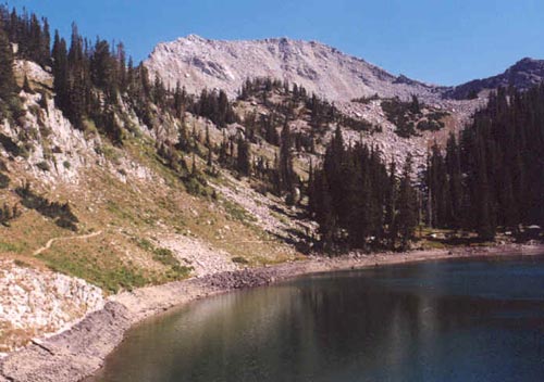
I returned in 2002 with Chandler, whom I had done several other hikes with over the years (including Superior). The plan was to finish the route from Red Pine that I had bailed out on five years earlier. We made quick time up the standard Red Pine trail to the lake (a beautiful hike in itself), with the high point being a squirrel jumping from a tree five feet in the air literally right in front of Chandler! We got to the lower lake (elev. 9,600') quickly and took a short break while taking in our first view of White Baldy beyond. We followed the trail around the lake and climbed one of the many tracks through the pine trees up to the higher bowl containing Upper Red Pine Lake (elev. 10,000'). The easiest route to this upper meadow is through the pine trees, but it takes you a little west of Upper Red Pine Lake (an easy side hike). There were several hikers here, but all were going to the more popular Pfeifferhorn.
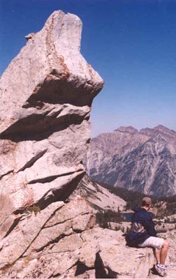
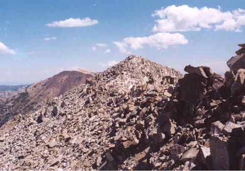
Between White Baldy and un-named 10,897 is a small peak. We found a nice tundra path that climbed up onto the ridge on the left side of this small peak (thus, not the usual route to the ridge for Pfeifferhorn). Reaching the ridge we were now up to 10,540' and the views were getting better and better. The climbing gets much more serious here. Some exposed scrambling is encountered, and you'll have to leave the ridge several times to get around pinnacles. The most impressive is a huge granite fang that is visible from just about anywhere in that upper bowl. I was glad to have Chandler here, since he is an experienced rock climber, he was very adept at finding the best routes past obstacles. After the fang, the ridge mellowed out a bit and we were able to find much dirt and tundra for a couple of hundred feet to very close to the summit ridge where it got tricky again. A ridge from the south meets the main summit ridge, which is filled with huge blocks of granite that must be crawled over and around. We reached the summit ridge at last, and could finally see the true summit in the distance to the east, just beyond a nearer false peak (elev. 11,260'). The false peak was an incredible pinnacle of granite! We bypassed the pinnacle on the left and slowly made our way over the rocks to the true summit. Another spectacular ridge led to the southeast (the ridge used from the White Pine/Silver Glance routes).
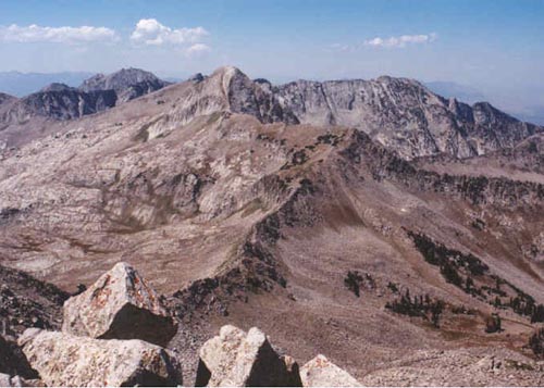
A final push up a narrow ledge with a wonderful crack led to the summit. Views were outstanding. Below we could see both the Red Pine Lakes and White Pine Lake, seperated by White Baldy's rugged north ridge. Across the canyon was the grand view of Cottonwood Ridge from Twin Peaks to Superior. West was the incredibly rugged Lone Peak Wilderness, with Pfeifferhorn nearest, and the high peaks of Chipman, Thunder and Lone in the distance. To the south we could see Utah Lake, Box Elder Peak and Mount Timpanogos, with Mount Nebo far away in the haze. Red Baldy looked small to the east, especially with the higher American Fork Twin Peaks beyond. We looked for a mailbox or summit register, but could not find one. After a 20 minute rest it was time to head down.
Neither of us was too anxious to take the same ridge back down since it was such slow climbing. We decided the north face didn't look so bad. We carefully downclimbed the steep but mostly stable rocks, and sure enough it was faster and easier than the west ridge had proved to be. Unfortunately waiting at the bottom of the face was the mother of all Wasatch boulderfields! The trip through this maze of huge boulders was some of the most tiring, slow, tedious hiking either of us had ever done, and we were much relieved when we finally made it back to the grassy part of the upper meadow. From here, it was all trail the rest of the way back! We stopped for a few pictures at Red Pine Lake before hiking the 3.2 miles back to our cars at the White Pine Trailhead.
White Baldy is a very difficult peak, and I would say I don't think I've ever done a peak requiring as many difficult climbing moves as this peak. The west ridge was very challenging, and even the boulderfield had a few spots that were very tricky because of the size of the boulders. It is not a climb I'd be too anxious to repeat, but it certainly provided spectacular scenery, and the entire experience was very rewarding.